Pit River (CA)
 The Pit River is the largest river in northeastern California; its watershed is 4,324 square miles. The mainstem Pit flows in a southwesterly direction through valleys and basalt canyons to Shasta Lake, where it eventually flows into the Sacramento River and San Francisco Bay.
The Pit River is heavily dammed for hydropower, and Pacific Gas & Electric (PG&E) holds several operating licenses in its system. The Pit projects are numbered by their age and upstream to downstream. The most upstream project, Pit 1, began construction in 1920. From 1923 to 1926, licenses were issued to construct Pit 3 and Pit 4 developments. In 1942, when PG&E renewed the license for Pit 3 and Pit 4, it also received authorization to construct Pit 5.
These dams, powerhouses, and diversions are captured under two operating licenses, “Pit 1” (FERC P-2687) and “Pit 3, 4, and 5” (FERC P-233). Each of these Pit developments involves at least one dam, a tunnel that carries diverted water out of the river, and a powerhouse – where power is generated and the water is returned to the Pit River. In the Pit 3, 4, and 5 developments, all of the tunnels are just over four miles long. This re-plumbing of the Pit River channels water around a combined 30 miles of natural riverbed.
By the time the Pit 1 operating license expired in 1995, PG&E had few environmental requirements. The Pit 1 forebay, only 12 to 15 feet deep, fluctuated as much as 3 feet per day in response to power demand. No minimum flows were required in any project reaches, leaving over 8 miles of the Fall and Pit Rivers dewatered and river levels downstream from the powerhouse highly unstable.
As required by the new Pit 1 license issued in 2003, PG&E releases steady water into the Pit River Canyon, and new release rates for the powerhouse slowed unpredictable fluctuations and curbed streamside erosion downstream. Punctuated flushing flows control unwanted vegetation from encroaching into the river channel and serve a dual benefit as a special whitewater release in the summer, and fall whitewater flows were implemented in 2011. For the first eighty years, the project had operated with no flow requirements. Since 2003, thanks to the new license, there is more balance.
When the Pit 3, 4, and 5 license was set to expire, PG&E adopted a new strategy: convene negotiations and create an agreement to settle principal issues. Convened in 1998, the Pit River Collaborative Team (PRCT) produced a settlement in 2003 that forms the framework of a new 2007 license. The license term – 36 years – is set to end at the same time as the Pit 1 license, for maximum coordination of the Pit River.
Several interests directed the licensing agreement. Bring water back into 22.5 miles of the Pit at slower naturalized rates. Enhance the top trout fishery in the Pit and in Hat Creek. Ensure that recreational resources – including fishing, whitewater, and the Pacific Crest Trail – were protected.
The PRCT agreement established new minimum flows at double or more the previous minimums. It also prescribed seasonal variation and a 0.5 foot-per-hour rate of change in releasing the flows, to mimic a natural hydrograph. These renewed flows and key habitat enhancements such as gravel replenishment and transporting wood downstream from the reservoirs will improve conditions for fish and wildlife. To be sure, PG&E will monitor aquatic life and water quality extensively over the life of the license, guiding adaptive management decisions for the river.
Through the settlement talks, key parties also resolved protection of the Hat Creek Wild Trout Management Area. Established in 1969, the Area is the first state-designated Wild Trout Creek. At the base of its 3.5 mile length, the state constructed a barrier dam to prevent the warmwater fishery of Lake Britton from invading the prized coldwater trout fishery [pictured at right]. A separate 2003 agreement, partially incorporated into the license, commits PG&E to funding 50% of the costs to maintain the barrier dam, and to providing $300,000 toward stewardship management over the next 30 years.
Relicensing Documents
Pit 3, 4, and 5
Pit 1
The Pit River Flows!
08/12/2013 - by Dave Steindorf
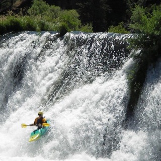
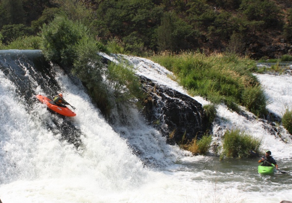
As part of the new license from the Federal Energy Regulatory Commission, PG&E released flows for paddlers for the first time this past weekend. Elite padder Macy Burnham had this to say about the run, "Cali has many amazing class III and Class IV rivers that are accessible to your average kayaker; unfortunately, it does not have many solid class IV rivers. The Pit 5 stretch from Madesi to Big Bend Bridge definitely fills that void. It is a great little stretch of whitewater."
2011 Fall Whitewater Boating Flows Approved for California's Pit River
08/03/2011 - by Megan Hooker
Whitewater boating flows will be coming to the Pit River in Northern California each October. On June 14, 2011, FERC issued an order approving four days of whitewater boating flows annually in the Pit 1 Bypass reach. These flows implement the 2003 license issued to PG&E by FERC for its operation of the Pit 1 Hydroelectric Project (FERC # 2687), and attempt to mitigate the loss of whitewater recreation on the Pit River due to the project. Fall 2011 releases have been scheduled for the weekends of October 1st/2nd and 15th/16th.
2010 Pit Releases Canceled? (CA)
05/16/2010 - by Dave Steindorf
The releases on the Pit River could be canceled this summer. The California State Water Resources Control Board has issued a 21 day notice that they will respond to the US Fish and Wildlife Service recommending that the releases on the Pit River should be canceled this summer due to concerns about Shasta Crayfish. Paddlers need to act now if these releases are going to be saved.
The contacts below include staff and volunteers working on this project. Make sure you are logged in if you wish to join the group.
| Title | Name | City | |
|---|---|---|---|
| Dave Steindorf | Chico CA | Details... |
Documents
Letter to Shasta County Board of Supervisors (9/5/2008)
Letter from AW regarding the Shasta County ordinance banning recreational use of the Pit #4 reservoir
Additional Information Request, Pit 3,4,5 (12/12/2001)
Intervention and Additional Information Request for Pacific Gas and Electric (PG&E) Pit 3,4,5 Project 233.
Pit 1 Easement Deed to BLM Pit River Campground (1/14/2022)
Pit 1 Easement Deed, Book 2197 Pages 170-176 and BLM MTP Plat
Associated News
Events
October 2024 |
||||||
| S | M | T | W | T | F | S |
|---|---|---|---|---|---|---|
|
29
|
30
|
1
|
2
|
3
|
4
CA, Pit 1 Releases
08:00 am -6:00 pm america/los_angeles Actual flow can vary depending on inflow - at least 900 cfs |
5
CA, Pit 1 Releases
08:00 am -6:00 pm america/los_angeles Actual flow can vary depending on inflow - at least 900 cfs |
|
6
CA, Pit 1 Releases
08:00 am -6:00 pm america/los_angeles Actual flow can vary depending on inflow - at least 900 cfs |
7
|
8
|
9
|
10
|
11
CA, Pit 1 Releases
08:00 am -6:00 pm america/los_angeles Actual flow can vary depending on inflow - at least 900 cfs |
12
CA, Pit 1 Releases
08:00 am -6:00 pm america/los_angeles Actual flow can vary depending on inflow - at least 900 cfs |
|
13
CA, Pit 1 Releases
08:00 am -6:00 pm america/los_angeles Actual flow can vary depending on inflow - at least 900 cfs |
14
|
15
|
16
|
17
|
18
|
19
|
|
20
|
21
|
22
|
23
|
24
|
25
|
26
|
|
27
|
28
|
29
|
30
|
31
|
1
|
2
|
Events
| CA, Pit 5 Releases |
Burney,CA
runs 09/06/14 - 09/08/24, next 08/03/24 [+] favorites |
| CA, Pit 1 Releases |
Fall River Mills,CA
runs 08/19/06 - 10/13/24, next 10/04/24 [+] favorites |