Alternative Access to Milsap Bar, Middle Fork Feather (CA)
After meeting with American Whitewater earlier this week, the Plumas National Forest in California has agreed to provide additional alternative access to the Middle Fork Feather during the road and bridge closure at Milsap Bar. The Forest Service originally planned to close Milsap Bar Road between June 20th and July 29th, 2011 to accommodate repairs to the Milsap Bar Bridge, road and campground. This road provides the primary access to the Middle Fork Feather, and the initial alternatives for access involved hiking steep trails. American Whitewater was pleased that Forest Service staff agreed to meet with us regarding devoping alternate options.
Directions for accessing the take out for Devil's Canyon and put in for Bald Rock Canyon during bridge repairs are described below.
Please note that these instructions may be subject to change and we encourage
you to check back with us before heading out. Edits will be made to this
posting.
Alternative Take Out for the Devil’s Canyon Section
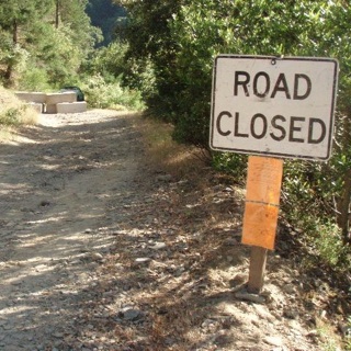
Boaters will need to access Milsap Bar from the south side of the river (see below for directions to the site). About a half-mile up from Milsap Bar several large concrete blocks block the road. Twenty yards up the road at a sharp bend there is a small road that leads down to the river. This road is marked with some red and black flagging in a tree near the road entrance, and will lead you to an area that is a short walk from the river. The Forest Service agreed to mark the take out with a sign that will be visible from the river. We recommend that you scout the take out before proceeding to the put-in.
The road to Milsap Bar is rough and rocky. We strongly recommend taking a truck or SUV with good clearance - coming out loaded down with boats, gear and people would test the limits of most conventional cars. The road is narrow with no turn around access and it is not advisable to take vehicles towing trailers.
Directions to Alternate Take Out for Devils Canyon of the Middle Feather
If you’re unfamiliar with the area, this route can be a bit challenging. Don’t try it without a good Forest Service map or a Northern California Gazetteer. The area contains a confusing maze of logging roads, and signs are generally unreliable and usually shot full of bullet holes. That being said, here is the lowdown on how to get there.
From Oroville take Hwy 162 (just like you were going to drive to Milsap Bar). Just a couple miles out of town, turn right onto Forbestown Rd. Go about 6 miles and turn left onto Lumpkin Road. Follow Lumpkin Road toward Feather Falls. Stay on Lumpkin past the Feather Falls Elementary School. A short ways past the school the road makes a fork. Stay right. Some maps show this as Mill Road but it’s the main paved road. (If you go past a fire station and the road turns to dirt you’ve missed the fork.) Stay on the main road 22N27, and go about 13 miles until you come to a large intersection where a number of roads come together. Turn left on the 22N94 (94 road) and follow the signs toward Cascade and Hartman Bar. Stay on the main paved road for about nine miles. You’ll go over a bridge on Fall River and another over the S. Branch. This is the put-in for the South Branch run. Continue on the main road past the turn-off to Hanson’s Bar. This is the road down into the Millsap Bar and Middle Fork Feather River. The road follows the ridge to the West for several miles before starting the long winding decent into Milsap Bar.
Once you drop down to where the river is visible you have to keep your eyes peeled for the trail that drops down to the river from the main road. It’s at a sharp right bend in the road, and within sight of the concrete blocks in the road and is marked with flagging. Vehicles cannot use this trail, and must turn around at the concrete blocks to head out the same way you came in.
Bald Rock Canyon Put In (Updated)
The Milsap Bar road is closed approxmiately 4.5 miles down from Bald Rock Rd. on the north side of the river. The road is gated approximately 2.5 miles north of Milsap Bar, and all access at Milsap Bar Bridge and campground is closed. Paddlers will need to leave vehicles parked off the road at the gate and hike 2.5 miles down the road to an access area downstream of the bridge. From this location, there are several trail options that will lead you to the river. One trail leads to an active mining claim site, and is marked with red and black ribbon. The other trail is further upstream, is unmarked and is a short but steep hike to the river. Vehicles will not be allowed past the gate due to road repair work, however hikers will be allowed past.
Important! You will need to download a Whitewater Boating Authorization form from the Plumas National Forest, print it out and place it on the dashboard of your car for both sites. This form is available here: www.fs.usda.gov/Internet/FSE_DOCUMENTS/stelprdb5313347.pdf. This authorization must be clearly visible, and all vehicles above the gate at the Bald Rock Canyon put in must be parked to the side of the road to ensure clear passage for contractors, materials delivery vehicles and forest service personnel.
Good luck, and have fun on the river!
Our ability to work to keep river access open is possible because of your support. Please consider making a donation, renewing your membership, or becoming a member of American Whitewater today!