AW Preserving Boating Opportunities on the Upper Colorado River
The Upper Colorado River Stakeholders Group will submit a draft resource management plan alternative for the US BLM's Kremmling and Glenwood Springs Field Offices. The Stakeholders Group is working together in good faith to develop a management plan in order to protect the outstandingly remarkable values (ORV's) identified in the BLM's 2007 Wild and Scenic River's Eligibility Report. The Stakeholders plan is being proposed to the BLM as a potential Wild and Scenic Rivers management alternative for the BLM Resource Management Plan revision process. The draft plan will be delivered to the Department of the Interior before the end of September.
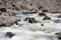
The alternative plan crafted by the group, seeks to balance permanent protection for recreational values in the Colorado River; water project yeild; flexability for water managers; and certainty for stakeholders. At the table in these negotiations are broad interests ranging from non-governmental agencies that manage water storage and delivery systems, to conservation groups working to protect river health and regionally significant recreational opportunitites. American Whitewater has worked for over two years to represent paddlers in the Stakeholder Process, ensuring the plan preserves dynamic in-channel flows by explicitly managing for flows that support a range of outstanding boating opportunities in Gore Canyon, Pumphouse, State Bridge and Glenwood Canyon.
With information collected from the Upper Colorado River Flow Preferences Survey's in 2007 and 2008, AW has identified a range of acceptable flows in the Colorado that provide for diverse whitewater challenges. By advocating for diverse boating opportunities, AW is defending critical dynamic flows for fish and wildlife habitat, sediment transport, and riparian health. American Whitewater has brought critical recreational needs data to the negotiation table and has committed to protecting the Colorado River by leveraging recreational flow needs to preserve ecosystem health.
|
|
Minimum Acceptable Flow |
Technical Flows |
Standard Flows |
High Challenge Flows |
Highest Acceptable Flow |
|
Gore Canyon |
700 |
750-1050 |
1050-2000 |
2000-2500 |
2500 |
|
Pumphouse |
700 |
900-1500 |
1500-3500 |
3500-5800 |
5800 |
|
Dotsero |
800 |
800-1400 |
1400-4500 |
4500-8800 |
8800 |
|
Glenwood Canyon |
1000 |
1000-1900 |
1900-4900 |
4900-9400 |
9400 |
American Whitewater 's Flow Preferences Table describes the results from surveying the flow preferences of both private and commercial paddlers for the Colorado River. In four segments of the Upper Colorado, AW examined the number of days (opportunities) these flows have been present in the system and identified the number of boating opportunities curently available in wet, typical and dry years. Click here for an example of Usable Days by Year Type for Gore Canyon. American Whitewater has indroduced and defended the resulting "Usable Days" metric as the recreational management criteria under the Stakeholder Plan.
Future opportunities for whitewater paddling are at risk as flows in the river are reduced by additional water storage and delivery. Between April and June, the average number of days when flows in the Colorado River are greater than 800cfs drops by 23% - thats over 20 lost Usable Days! American Whitewater is working to ensure that these opportunities are not impacted by future conditions, and that sufficient flows are provided to protect the recreational Boating ORV.
The Management Plan Alternative is being prepared by:
Grand County, Eagle County, Summit County, Northwest Colorado Council of Governments, Colorado River Water Conservation District, Blue Valley Ranch, Middle Park Water COnservancy District, Colorado Springs Utilities, Aurora Water, Denver Water, Norhern Colorado Water Conservancy District, Trout Unlimitied, American Whitewater, The Wilderness Society, Colorado River Outfitters Asociation
In consutation with: Colorado Department of Natural Resources, Colorado Water Conservation Board, U.S. Bureau of Reclamation, U.S. Forest Service
In Spring of 2010, the BLM will release it's Draft Environmental Impact study for the Managment Plan Revision Process. Paddlers will be able to comment on the plan and provide input to the BLM on management of the Colorado River. The draft Stakeholders Plan will be posted to the AW site when available.